Recommendation for individuals using a screenreader: please set your punctuation settings to "most."
Descriptive Statements:
- Apply basic geographic terms and concepts (e.g., latitude and longitude, absolute and relative location, cardinal and intermediate directions, assimilation, demographic cycle, complementarity, sustainability).
- Demonstrate knowledge of the properties and functions of geographic representations (e.g., maps, globes, graphs, diagrams) and how they can be used to investigate, analyze, and solve geographic problems and communicate the results.
- Demonstrate knowledge of the properties and functions of geospatial technologies (e.g., Internet-based mapping applications, geographic information systems, global positioning systems, remote sensing, geographic visualizations) and how they can be used to investigate, analyze, and solve geographic problems and communicate the results.
- Interpret geographic information about people, places, and environments presented in various visual formats (e.g., maps, charts, tables, population pyramids, images).
- Demonstrate knowledge of the location and uses of natural resources in the United States and the world and apply knowledge of the physical processes that influence the formation and distribution of renewable, nonrenewable, and flow resources.
- Identify and describe physical, political, and cultural features of the world (e.g., landforms, bodies of water, climate zones, countries, regions, population centers, linguistic groups) on maps of different types and scales; and use geographic skills to understand and analyze the spatial organization of people, places, and environments on Earth's surface.
- Define and apply the concepts of region and place, identify major regions of the United States and the world determined by various criteria (e.g., landforms, climate, population, economic characteristics), and explain how and why regions change over time through physical and human processes.
- Use modern and historical maps and other geographic tools to trace the development of human settlement and the movement of people, products, and ideas and to analyze how historic events have been shaped by geography.
Sample Item:
Use the map below to answer the question that follows.
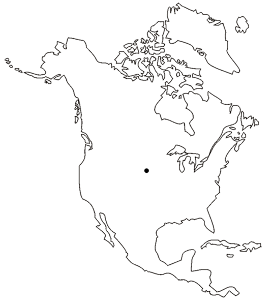
An outline map of North America, including the Great Lakes. One point is identified about one third of the way between southern Lake Michigan and Puget Sound or Vancouver Island.
People living in the place marked on the map would most appropriately consider that place to be part of which of the following regions?
- Great Plains and western United States
- Rocky Mountains and Great Lakes
- southern Canada and Mississippi River Valley
- Midwest and Great Basin
Correct Response and Explanation (Show Correct ResponseHide Correct Response)
A. The place identified on the map corresponds approximately to South Dakota, which can be determined by interpolating between the visible landmarks of Lake Michigan, Lake Superior, and Vancouver Island. South Dakota lies in the region of the Great Plains, which can also be considered a subset of the greater western United States.
Descriptive Statements:
- Analyze physical, economic, and political factors that have promoted or impeded the movement of people and the effects of human migrations on physical and human systems.
- Analyze patterns of the diffusion of technology, agricultural practices and products, and cultural and religious practices and the effects of such diffusion on human societies.
- Analyze the effects of physical environments and the availability of natural resources on human activities, settlement patterns, and land use.
- Analyze opportunities and challenges posed by urbanization for cities and their surrounding regions.
- Examine the opportunities and constraints placed on human societies by the physical environment and how people have used a variety of strategies to adapt to the environment.
- Analyze ways in which human societies modify the physical environment and the effects of those modifications on both the environment and on human societies.
- Examine social, political, and economic consequences of bias for historically marginalized groups and the population as a whole.
- Demonstrate knowledge of current patterns of trade, communication, and interdependence among countries.
- Analyze the causes and effects of globalization.
Sample Item:
From a geographic perspective, World War II 2 can be considered to have been caused, in part, by which of the following constraints imposed by the physical environment on one of the combatant nations?
- the lack of energy resources in the Japanese Empire
- the lack of arable farmland in the Soviet Union
- the lack of old-growth forests in Nazi Germany
- the lack of potable water in fascist Italy
Correct Response and Explanation (Show Correct ResponseHide Correct Response)
A. World War II 2 involved multiple theaters of operations with disparate causes, but a major motivation of the Japanese Empire in the 1930s 19 thirties was the desire to gain resources to sustain their industrial growth. Japan is endowed with negligible amounts of petroleum, natural gas, and coal, as well as other resources including iron ore, tin, and rubber. Western powers had already established colonies and spheres of influence in resource-rich regions, such as the Dutch East Indies. In 1938 19 38 the United States began imposing an escalating series of trade restrictions on Japan, culminating in an embargo on oil and gasoline in the summer of 1941 19 41 . This further pressured Japanese policymakers to undertake the attacks on Hong Kong, Malaya, Singapore, Thailand, and Hawaii on December 7– to 8.

 View Cart